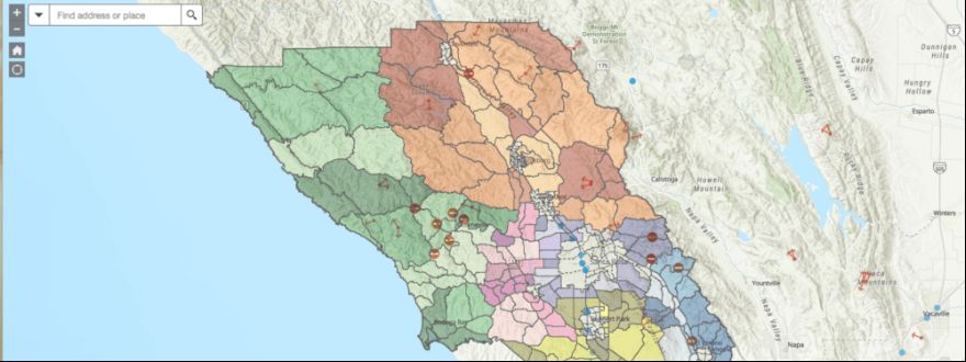
The County of Sonoma has released official evacuation zone maps designed to help residents be ready for an emergency that may require them to evacuate their homes, the Sonoma County Sheriff’s Office announced today.
The County is establishing standardized evacuation zones for Sonoma County. In the past, evacuation zones were different for each incident. Now zones will remain the same, and residents are urged to learn their evacuation zones and be ready to go when an evacuation order is issued. The maps show evacuation zones for unincorporated areas in Sonoma County as well as most of the incorporated communities.
“With wildfire season upon us, these official evacuation zone maps are an essential part of doing everything we can to make sure our families and neighbors are safe if disaster strikes,” said Supervisor Lynda Hopkins, Chair of the Sonoma County Board of Supervisors. “We all need to learn our zones and know what to do and where to go if our zone is ordered to evacuate.”
To find your zone, go to: https://socoemergency.org/evacuation-map/
County emergency officials say that knowing your evacuation zone number is a key element of a disaster preparedness plan. Residents are urged to write down their zone number and consider learning the zones near their residence to help them better understand the level of risk to their property when an emergency arises. It also is important to know the evacuation zone where you work and where your children’s schools are.
During the Kincade Fire in October 2019, for example, more than 190,000 residents in the County eventually were ordered to evacuate their homes.
The Sheriff’s Office was in the process of developing the evacuation zone maps and nearly finished when the Walbridge and Meyers fires hit in August 2020, followed by the Glass Fire a month later. The decision was made to release the draft maps at that time in response to the latest large fire events. Feedback that the Sheriff’s Office received from the community and first responders after those fires has been incorporated into the final, official evacuation zone maps that are being released today. Evacuation zone numbers in unincorporated Sonoma County now have SON before the number.
To help first responders evacuate neighborhoods quickly and safely during a disaster, the Sheriff’s Office is giving away evacuation tags to residents living in unincorporated Sonoma County and its contract cities, Sonoma and Windsor. Each tag comes with a bilingual instruction flyer.
“Evacuation tags are a crucial tool to help us more quickly ensure that neighborhoods are evacuated during a disaster,” said Sheriff Mark Essick. “When they evacuate, residents tie the tag in a location that is highly visible from the street. This saves time because first responders can immediately check the next home. As we all know, seconds can count during evacuations and we are excited to bring this new time-saving tool to our residents.”
Residents are encouraged to place the tag in a location that is most visible to first responders who are on the street. This could be a gate, a mailbox, or a front door. If there is more than one home on the property, make sure all homes are evacuated before placing the tag near the street. Residents also are urged to sign up for emergency alerts to ensure they receive critical updates, including evacuation alerts.
Register at:
● SoCoAlert.com or (707) 565-1369
● Nixle.com or text your zip code to 888777
Residents also should make sure they receive Wireless Emergency Alerts (WEA). This federal system works exclusively by sending a text message to cell phones, much like an Amber Alert. A WEA message is accompanied by a special warning tone. To activate this alert, residents should make sure their cell phone settings are set up to accept these emergency and public safety alerts.
Emergency officials say everyone should have a disaster strategy that includes an emergency kit and a plan to stay safe and informed as events unfold. More information on getting ready is available at https://socoemergency.org/get-ready/
More information on evacuation tags, including photos of how to display them, is available at: https://www.sonomasheriff.org/evac
Tags are available at Sheriff’s Office stations during business hours:
● Main Office, 2796 Ventura Ave., Santa Rosa
● Main Adult Detention Facility, 2777 Ventura Ave., Santa Rosa
● Valley Substation, 810 B Grove St., Sonoma
● River Substation, 16225 First St., Guerneville
● Sonoma Police Department, 175 First Street West, Sonoma
● Windsor Police Department, 9291 Old Redwood Highway, Bldg. 300, Windsor
Evacuation packs are also being distributed by the County through organized neighborhood groups and at County libraries. The packs are available in English and Spanish and include a personal emergency plan template, evacuation checklist and tips for power shutoffs. The packs are being distributed to 10,000 households. For more information visit: sonomalibrary.org/emergency-preparedness


